It shouldn’t be a surprise that the warmest months of the year are also the most severe given abundant heat and humidity. Certain months are more prone to certain hazards however.
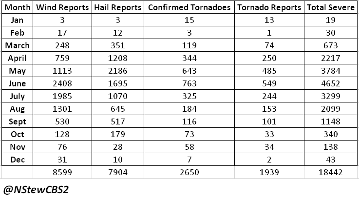
Total Iowa severe weather reports.
May, June and July are the most active in terms of reports accounting for more than half of the entire year’s worth of severe weather.
A breakdown of severe weather reports by month.
A breakdown of the reports shows certain months are more at risk for certain hazards. March, April and May see more hail reports than wind reports. June, July and August see much more wind damage reports than any other type of severe weather.
The tornado threat peaks in June in Iowa, but April through July are the most common months to see a tornado.
In January there have been more tornado reports than both wind and hail reports combined.
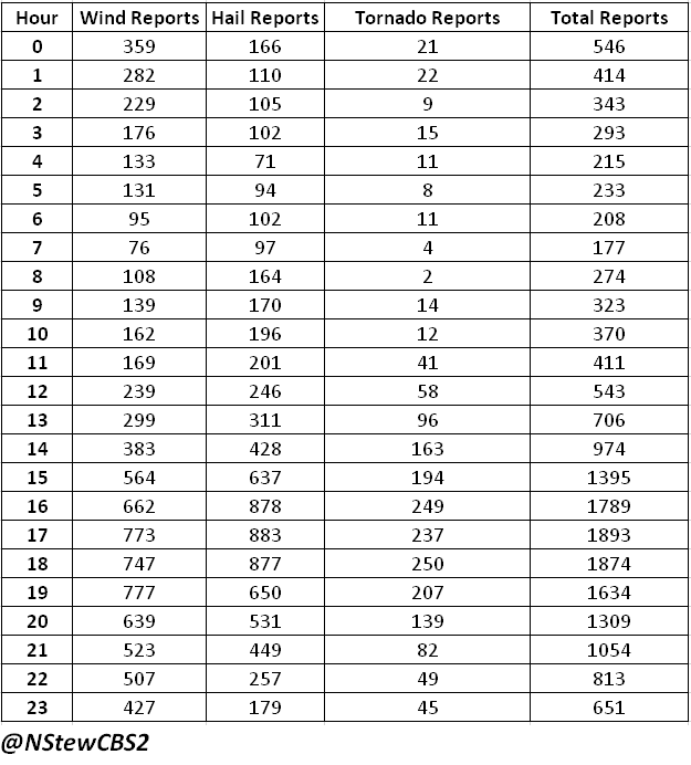
Hail, wind and tornado reports by hour.
The months most at risk of severe weather should be as obvious as the peak times of severe weather for the same reasons. When looking at total number of storms reports (hail, wind, tornadoes) the peak times are 3 p.m. through 9 p.m., with the peak hours from 5 p.m. to 7 p.m.
Severe weather report type by hour.
The severe weather type by hour is interesting to look at and makes sense conceptually with what you would typically expect. Hail is the dominant severe threat 7 p.m. through 5 a.m. This is likely due to the very common occurrence of elevated convection at night. It is quite common no matter the time of year for strong storms to develop north of surface boundaries creating large hail.
Damaging wind gusts peak through late morning into the early and mid afternoon hours. Storms during this period are more likely to be surface based thus creating damaging wind gusts.
The tornado threat is maximized through the afternoon and early evening hours. To learn more about the tornado climatology in Iowa, you can find my other research page dedicated to just tornadoes. That page also uses actual confirmed tornadoes as opposed to tornado reports.


