A multi-day heavy rainfall event continue to take shape across the Upper Midwest as we head into the weekend with a high-end threat of flash flooding from southern South Dakota, through southern Minnesota into northern Iowa, and western Wisconsin.
Pockets of 8” of rain are possible in localized areas due to training thunderstorms, or storms hitting the same places over and over again. The Weather Prediction Center has a Moderate Risk, or a Level 3 of 4 risk, for flash flooding across this area.
Weather Prediction Center 48-hour rainfall forecast.
The Weather Prediction Center has a broad area of 3-5” of rainfall across a large area Friday and Saturday. This is over areas which have already picked up a rather significant amount of rainfall in recent weeks. With saturated soils and rivers/creeks already running high, this will cause flood potential.
National Weather Service alerts.
Flood Watches are in place across a broad are of South Dakota into Wisconsin ahead of the rainfall threat, depicted in dark green.
The HREF probability matched mean product.
Using high-resolution forecast models, we can see a large area at risk for torrential rainfall over the next 48 hours. The HREF PMM, or probability matched mean, product is a very good tool for indicating the high-end potential of a rainfall event. This model product is indicating areas of 7-10” of rainfall being a possibility in localized areas.
This PMM product typically over does the coverage of the heavy rainfall, however it is very useful for finding the "reasonable worst case scenario.” Northern Iowa will be most at risk with this system.
Based on historical standards, the amount of moisture this time of year will be at a record value for the time of day across northern Iowa, southern Minnesota and western Wisconsin. Precipitable water, or PWAT, values will be in excess of 2.0” which will lead to rapid rainfall accumulation in any thunderstorms that develop.
This, sitting over the same areas that indicate the potential for widespread 5-8” of rain, is a big red flag for the potential flash flooding and river flooding.
Saturday morning’s forecast map.
A stationary boundary draped across the region is the focus for training thunderstorms hitting the same places over and over again. This stubborn boundary will not be moving much over the next 48 hours.
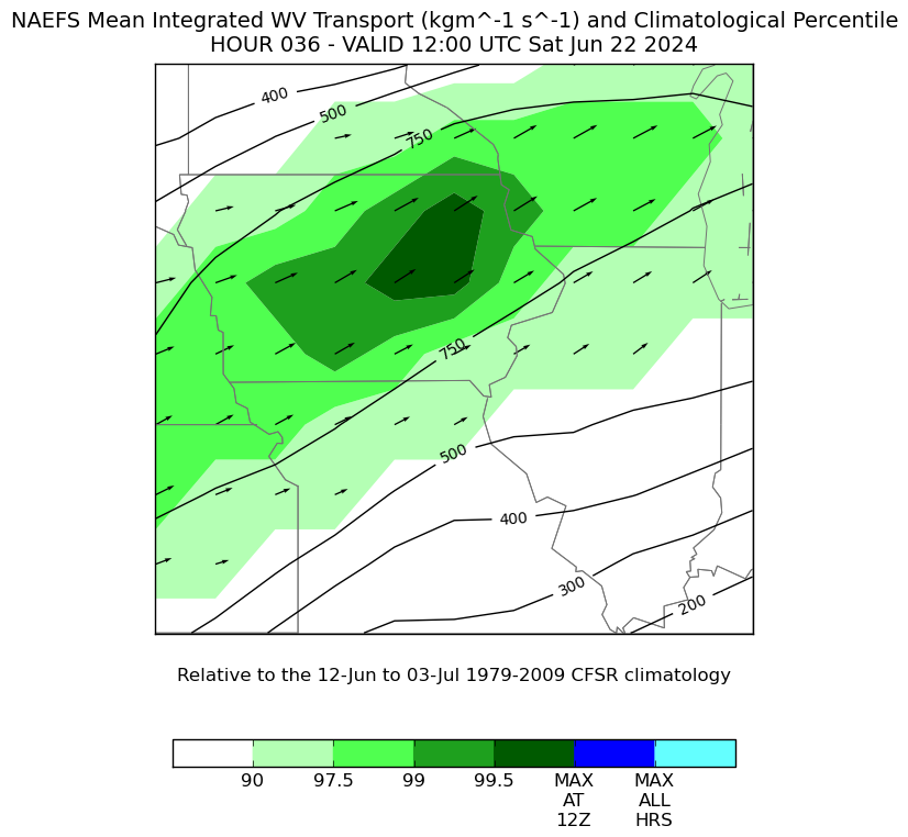
Water vapor transport climatology.
The concern is the strong moisture transport, at near record values (99.5th percentile), pushing into and crossing this boundary which will help storm formation.
All in all, this has all the classic signals for a widespread flood threat across the Upper Midwest.
As always, turn around, don’t drown. Never drive through a flooded roadway. Especially at night, it’s difficult if not impossible to determine how deep the water is, and it’s also impossible to know what the road looks like below the water. It could be completely collapsed!
More to come…
-Meteorologist Nick Stewart


