Saturday March 5 was the first severe weather day in Iowa in 2022. The event promised damaging wind gusts with a few tornadoes also likely. The outcome of the day far exceeded the expectations of most storm chasers and meteorologists as an EF-4 tornado carved a nearly 70-mile-wide path of damage through central Iowa.

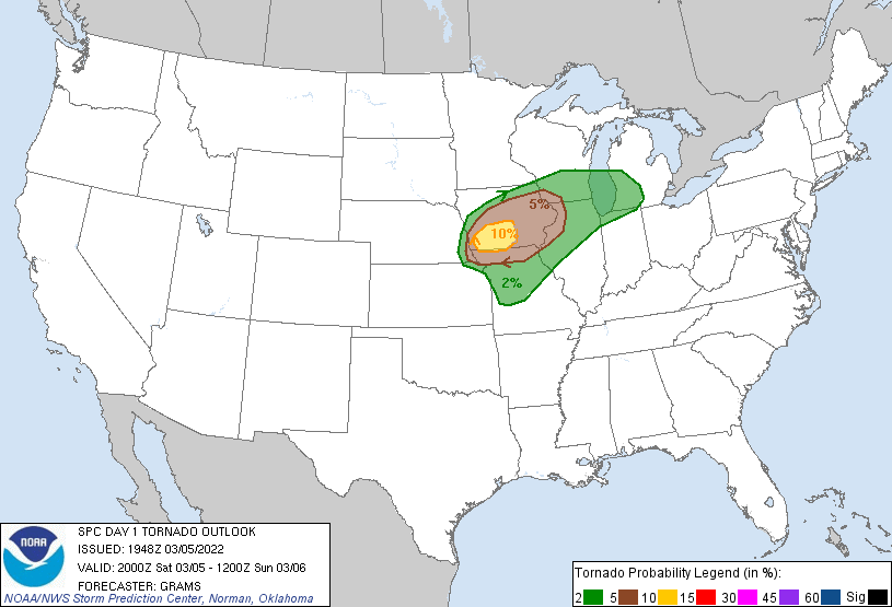
The Storm Prediction Center upgraded the overall severe weather risk to a Level 3 of 5, an Enhanced Risk, with the 16:30z (10:30 a.m. CST) update. Later at 20:00z (2:00 p.m. CST) the Enhanced risk was kicked out farther west, and a 10-percent tornado probability was outlined.
Shortly after at 2:07 p.m. CST a Tornado Watch was issued for southwest Iowa, far northwest Missouri and the southeastern two counties in Nebraska where storm initiation was occurring.
At this point, we were headed through Atlantic, Iowa headed to storms forming and crossing into southwest Iowa. Points to consider when chasing on March 5:
Storm motions would be pushing 50-60mph, therefore you do not necessarily want to jump on the storms right away.
The road network is fairly decent in Iowa aside from a few river valleys, so “stair stepping” these roads northeast was going to be the way to keep up. Knowing paved roads was key.
Tornadoes were certainly likely with any supercells that formed, but linear growth during the event was anticipated. Therefore sticking with more discreet storms early that have best access to warm, moist air was critical.

By 2 p.m., dewpoint values in southwest Iowa have surpassed the critical 60-degree mark. Moisture, which at one point was a concern, was no longer an issue. Low 60 dews with mid-60 temperatures was a recipe for robust thunderstorm development with this cold-core setup.

At 4 p.m. as Severe Thunderstorm Warnings and Tornado Warnings were in place, CAPE in the lowest 3km of the atmosphere reached levels over 200j/kg. This was coupled with extreme low-level wind shear. A strong updraft could stretch this surface-vorticity into the vertical leading to tornado development.

Storm Relative Helicity in the lowest 500m of the atmosphere was approaching 200m2/s2. When combined with the 200j/kg+ 0-3km CAPE, that is all you need for tornadoes with this pattern. The key was storms remaining discreet which indeed unfolded with three notable supercells taking shape.

The first solid supercell we had eyes on was near Villisca, Iowa on US34. The storm was certainly organized but something visually was lacking.
Of note, another interesting sight on this day was the vast amount of migrating birds in the air. If you look above the base of the storm, there is a large flock of fowl flying.
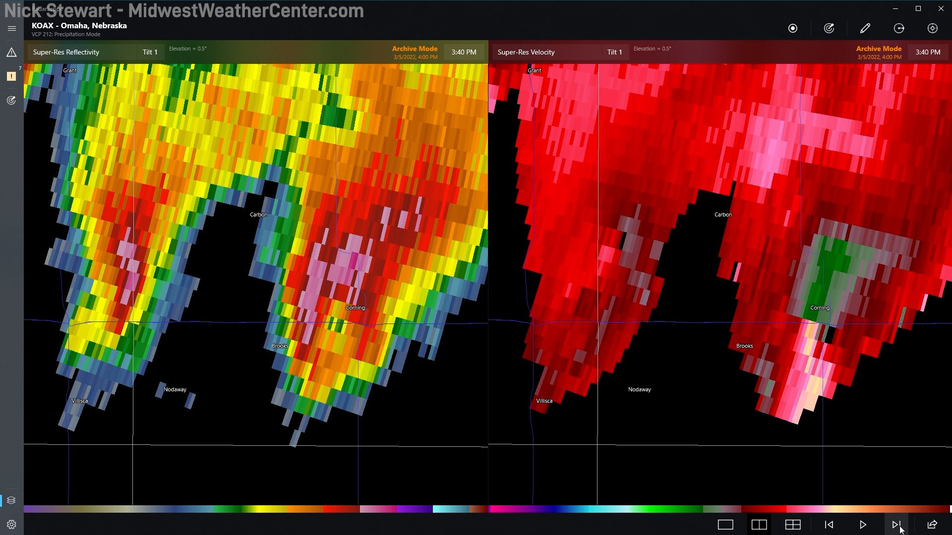
We decided to abandon this storm (left storm above) and focus on the next storm to our east which was over Corning, Iowa. On radar the storm had a classic BWER (bounded weak echo region) and a strong couplet. With nothing out ahead of the storm, this was sucking in clean air.
We witnessed a brief needle tornado before the storm underwent a cycling process. As it approached Creston, Iowa the storm developed a pronounced RFD cut/clear slot cutting into the meso. This became very apparent to me it was about to produce potentially a significant tornado given the other parameters in place.

We witnessed another brief tornado northwest of Creston as we struggled to keep up and get ahead of this dominant supercell. As we turned onto Highway 169 we watched the development of the EF-4 wedge tornado. We were on the low-contrast side of the storm which made viewing rather difficult in the heat of the moment.
The structure was very pronounced with an RFD cut/clear slot and a beefy wall cloud. The funnel of the tornado was visible for a short time as we approached the city of Winterset, Iowa.

Tornado damage was observed south of Winterset and east of town. At the moment we thought the tornado missed the vast majority of town. Our damage was relatively minor to trees, power poles and outbuildings like garages and sheds. We were not aware of the scope of the damage in town until well after the chase.
As this supercell continues to threaten more populated areas, and heading into my TV coverage area in eastern Iowa, we decided to keep sticking with it to provide ground truth for the National Weather Service and local media.

Just west of Prairie City we had our best view of the monster as it briefly poked out of the rain. The dark inner-mass filled with debris as rain bands wrapped around the exterior. Again, we knew this tornado remained on the ground and continued to be a threat to many more people.
— Nick Stewart (@NStewCBS2) March 5, 2022
#Tornado crossed highway 117 just south of Colfax. @NWSDesMoines #iawx
— Nick Stewart (@NStewCBS2) March 5, 2022
Local media feel free to use photos pic.twitter.com/lvsJEPkSwI
We ended up crossing the damage path numerous times between Winterset and Newton. It was our belief based on our damage encounters this tornado was likely on the ground the entire path - which the National Weather Service did confirm in its survey.

The discreet supercell with a big debris ball passed just southeast of the Des Moines metro area. At this point the tornado trekked more than 50 miles, causing damage in Prairie City, Colfax and Newton.

Dark settles in as the clock ticked closer to 7 p.m. Passed Newton, the storm clearly was no longer producing a tornado but had a big mesocyclone, and wall cloud/funnel features. Our source of visuals going forward was going to be lightning strikes and potential power flashes as power poles were brought down by the storm.
At this point we were feeding back reports to the National Weather Service and our station, KGAN-TV in Cedar Rapids, as the storm moved into the coverage area. Tama County was now under a tornado warning causing us to go wall-to-wall, or continuous coverage.
We hit issues with cell service causing live video to be limited right as the storm went on to produce two more tornadoes.

Visible in the lightning flashes, a big stovepipe tornado was visible in southern Tama County. We quickly got reports to the NWS/KGAN and helped warn the public of this dangerous tornado later rated EF-2.
As the tornado moved into the rural Tama city area, several power flashes were observed. Thankfully for the city, the tornado passed about a mile south of the town but did hit a home in rural Tama causing EF-2 damage. No injuries were reported.
We continued chasing the storm deeper into eastern Iowa as the storm was losing its strength. By this point, the instability was waning, but the storm was not done yet. Another EF-1 tornado was produced in Benton County affecting areas around Garrison and Vinton.

No injuries were reported in Vinton despite a mobile home park taking a hit, as well as a large factory which had its roof shredded off. This was likely in part due to very good warning lead time by the NWS.
In all, 13 tornadoes hit the state of Iowa during this event.
The strongest was the EF-4 in Winterset with winds estimated at 170mph. This tornado unfortunately killed six people. A seventh person was killed by an EF-3 tornado south of Chariton.