Contextualizing the 2024 Hurricane Milton tornado outbreak in relation to other high-impact tropical cyclone tornado outbreaks
Nicholas Stewart, Midwest Weather Center
Abstract
On October 9, 2024, Category 3 Hurricane Milton made landfall about five miles west of Sarasota Florida in the late evening hours. Prior to landfall, the largest and second-deadliest tornado outbreak on record in state history took place across the Florida Peninsula with nearly 50 confirmed twisters. While well forecast, this event was quite unusual given the number of stronger EF-2/EF-3 twisters and the highly visible nature of them. This project runs a reanalysis on all tropical-system-induced tornadoes in Florida since 1995 to find the conditions that led to this historic event. Anomalous overlap of MLCAPE and 0-1km shear/SRH was a strong contributor leading to a volatile environment rare for Florida. A large area of mid-level dry air between 700-500mb was analyzed wrapping into southern Florida ahead of Milton’s landfall helping increase convective instability.
1. Introduction
a. Event Overview
Hurricane Milton made landfall on October 9, 2024 near Siesta Key, Florida at approximately 8:30 p.m. local time as a category 3 storm with maximum sustained winds of 120mph/205km/h. This was the third hurricane to make landfall in Florida during the 2024 hurricane season behind Debby and Helene.
Tornadoes produced by tropical systems are not uncommon, but some tropical events produce larger-scale tornado outbreaks while others do not. Schultz et al. (2009) studied nearly 1800 tornadoes associated with landfalling tropical systems between 1950-2007. Results show less than 14 percent of these twisters were rated F/EF-2 or higher. In the case of Milton, approximately 20 percent of the tornadoes were rated EF-2 and EF-3. This puts it closer to the non-TC tornado percentage in the US reaching significant (F/EF2+) status (Shultz et al. 2009)
What made Milton particularly memorable was the tornado event that evolved ahead of landfall in southern and central Florida. There were at least 46 tornadoes confirmed by the National Weather Service offices across the state, nearly doubling the previous tornado outbreak record in Florida of 24 tornadoes with Debby in 2012.
The strength of the tornadoes also stood out with Milton. Between 1995-2023 there were five EF-3 tornadoes associated with landfalling tropical systems in the United States – Hurricane Milton had three, in addition to six EF-2 tornadoes. The EF-3 tornado in Fort Pierce, Florida killed six people – the deadliest tropical-system-induced tornado since 1995.
The tornado outbreak was relatively well forecast. At Day 3, the Storm Prediction Center issued a Slight Risk for the southern Florida peninsula. At Day 2, the Slight Risk continued with a five-percent tornado outlook in place. “The increasing flow field across Florida will coincide with peak heating, resulting in sufficient instability to maintain isolated stronger updrafts within outer rainbands that may approach the area by afternoon.”
The 06z Day 1 Outlook upgraded the severe weather risk to an Enhanced Risk with the addition of a 10 percent hatched outlook area, though the subsequent outlooks at 13z and 1630z would better capture the area most at risk.
“The HRRR suggests that cells within the second band will remain semi-discrete. All of this points to the possibility for a relatively confined tornado cluster this afternoon in the area to the west and north of Lake Okeechobee. A strong tornado or two could occur during the mid to late afternoon, when instability and shear will be locally maximized.”
A single tornado watch was issued by the Storm Prediction Center. At 1215z a watch with a “high” 80 percent chance of tornadoes was issued until 01z on Oct. 10.
A total of nine mesoscale discussions were put out by SPC as the event unfolded, highlighting at times the threat for strong tornadoes.
The first tornado of the day occurred at 0337z in the Florida Keys with the last tornado at 2153z near Cape Canaveral, Florida.
Again, at 46 tornadoes, this was the largest tornado outbreak on record in the state of Florida, and nearly doubled the previous record which was also a tropical event.
b. Historic Context for Outbreaks
Tornado outbreaks on the Florida peninsula had limited research prior to 1996. Previous studies, like Fujita (1987), looked at conditions favoring tornado outbreaks have been mainly geared towards the Central Plains. Grazulis (1993) started the process of defining a tornado outbreak by considering one as six or more tornadoes formed by the same weather system.
Hagemeyer (1996) attempted to apply a definition for Florida peninsula outbreaks specifically by giving some guardrails. Between 1950-1994, out of 998 total days with at least one tornado, only 23 reached the criteria set by Grazulis (1993) of having six or more tornadoes. Therefore, Hagemeyer instead defined a tornado outbreak as four or more tornadoes which bumped the total number of events to 48. Those tornado events also needed to be close geographically. This would eliminate events caused by sea breeze collisions on opposite coasts or other mesoscale events.
The Florida Peninsula was also defined as all areas south of 30°N, which eliminates several cases, especially tropical events, that occurred in the Panhandle region. This includes Hurricane Ivan in 2004 as an example which produced 16 tornadoes, but outside of the geographic restriction.
Another trait of a Florida Peninsula outbreak required four or more tornadoes to occur with a maximum of four hours between events. When looking at tropical system outbreaks specifically, this four-hour window is important as outer bands could spawn tornadoes well before the main part of the storm, or the main thrust of tornadic activity. This could also cause separate outbreaks related to the same system.
Using the Storm Prediction Center Tropical Cyclone Tornadoes finder (NOAA, 1995-2023) and applying the four-tornado minimum within four hours of each other, the number of tornado outbreaks associated with tropical systems meeting the Hagemeyer (1996) definition reached 14 events from 1995-2023 (Table 1). Hurricane Milton would be event 14.

TABLE 1. Florida Peninsular Tornado outbreaks associated with tropical system based on criteria set by Hagemeyer (1997) from 1995-2023. Gabrielle 2001 is listed twice due to a morning and evening event, separated by more than four hours, but each meeting the outbreak criteria.
Studies on tornado outbreaks associated with landfalling tropical systems in Florida, like Baker et. al (2009) which focused specifically on Hurricane Ivan in 2004 discuss landfalling supercells and immediate land interactions due to increased friction and radar indications of an increase in VIL and mesocyclone strength. Mesocyclones in cells were found to increase in rotational velocity and soon produced tornadoes. Rao. Et. al. (2005) discussed in more general terms that circulations over the ocean that can produce tornadoes upon land interaction.
Milton was a unique case study as supercells also formed over the Florida Peninsula instead of mainly tracking from over the ocean. Still, this land interaction is relevant for other outbreaks that will be discussed in this research and used to determine a climatology.
c. Role of Severe Parameters in Tropical Tornadoes
Tornadoes and supercells have long been studied with specifics in their thermodynamic and kinematic environments. Markowski et al. (2003) determined wind profiles in the lowest 1km AGL were a major differentiating feature between storms that produce tornadoes and those that do not. This applies to both SRH and shear vector magnitudes. Low-level wind fields in tropical systems contain higher-end values in the lowest 1-1.5km as addressed by Bogner et. al (2000), with the highest wind shear closer to the center of the storm – though CAPE is typically more limited.
Molinari and Vollaro (2008) studied Hurricane Bonnie in which the 0-3km SRH was in excess of 1000-1300m2/s2 using observed land-based soundings. Molinari and Vollaro also discussed that the vertical wind shear in the lowest 1-2km of a tropical system making landfall was stronger in events producing tornadoes than those that do not. Molinari and Vollaro (2010) added onto the Bonnie research by finding helicity in the right half of a strongly-sheared storm was four times stronger than the left half. Additionally, common severe weather parameters such as Superell Composite and the Energy Helicity Index exceeded thresholds used for supercells.
Baker et. al (2009) used soundings, both launched from the land via balloon and via plane over the sea in various quadrants of the storm and in analysis determined the environment for tornadoes was at its peak in the right-front (RF) quadrant. This research went so far in saying the right-front quadrant was the only area worth focusing on.
For Milton, nearly all tornadoes on Oct. 9, 2024 occurred in the right-front of the storm (Fig. 1) which maximized the low level wind shear and helicity.

Figure 1: The tornadoes associated with Hurricane Milton in relation to the storm’s center shows the vast majority in the right-front quadrant, an area that has the enhanced low-level wind shear and helicity.
d. The Meteorological Setup for Milton
As Milton approached the Florida Gulf Coast a volatile environment was setting up over the southern peninsula with an overlap of strong 0-1km storm relative helicity (SRH) and mixed later convective available potential energy (MLCAPE).
Visible satellite imagery via GOES-East/GOES-16 showed filtered sunshine to high cirrus to mostly sunny skies in the eastern and southeastern peninsula. This allowed low-level lapse rates to increase quickly.
Special 18z soundings were released from Miami and Tampa Bay as the tornado outbreak was just beginning to unfold.
On the east side of the Peninsula, 18z MFL sounding (Fig. 2) had quite the thermodynamic environment in place. Surface-based CAPE was measured just shy of 3600 j/kg with MLCAPE a little over 2300 j/kg. The 0-3km CAPE (3CAPE) was observed at 158j/kg.
TBW under the influence of more cloud cover and precipitation by 18z (Fig. 3) had a more meager SBCAPE of 781j/kg with MLCAPE of 357j/kg.

Figure 2: An 18z special sounding from MFL shows the very impressive thermodynamic environment setting up over the eastern and southeastern Florida Peninsula as the tornado outbreak was about to begin.
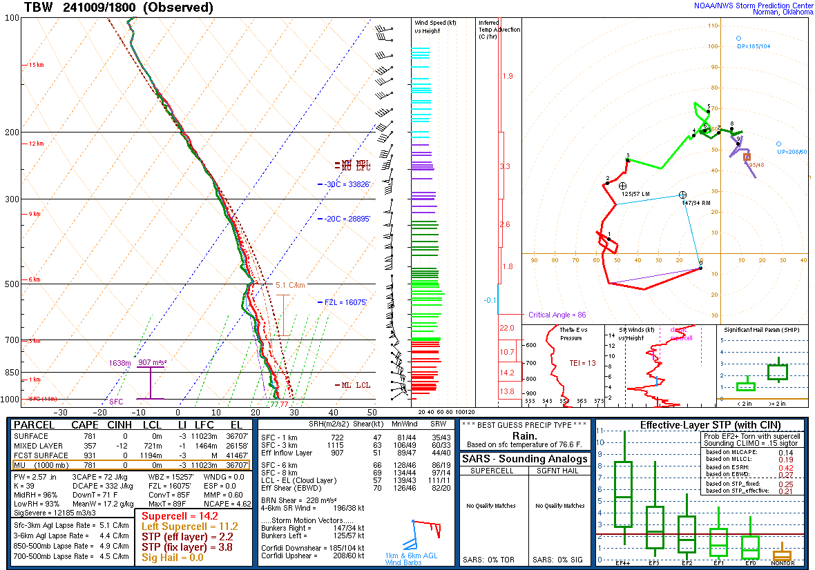
Figure 3: An 18z special sounding from TBW shows the very impressive kinematic environment setting up over the western Florida Peninsula as the tornado outbreak was about to begin.
Kinematically, TBW was much more volatile. SFC-1km SRH eclipsed 700m2/s2 with 47kts of 0-1km shear. Meanwhile MFL was measuring SFC-1km SRH at 148m2/s2 and 20kts of SFC-1km shear. As time went on the better wind shear would spread eastward over the much stronger thermodynamics setting the stage for the impressive tornado outbreak.
As the center of Hurricane Milton continued to push closer to making landfall near Tampa, RAP reanalysis using SounderPy (Gillett, 2024) soundings avoiding as much convective feedback and influence as possible show the enhancement of the 850mb winds increasing the low-level shear between 18z (Fig. 4) and 21z (Fig. 5) at Fort Pierce, Florida.
At 18z the 0-1km SRH was analyzed at 102 m2/s2 with effective inflow SRH at 180 m2/s2. At 21z the 0-1km SRH climbed to 144 m2/s2, but the effective inflow SRH climbed all the way to 405 m2/s2. Trends continued to show the increasing overlap of thermodynamics and kinematics.

Figure 4: An 18z RAP reanalysis for Fort Pierce, Florida indicated a volatile environment for tornadoes with SBCAPE more than 3600 j/kg and 0-1km SRH 102 m2/s2.

Figure 5: A 21z RAP reanalysis for Fort Pierce, Florida shows an increase in low-level wind shear with 0-1km SRH up to 144 m2/s2 with a substantially higher effective inflow SRH.
Another thing to note on the 18z RAP reanalysis sounding at Fort Pierce, Florida is the relative humidity from 3-6km, approximately the 700-500mb region, which was analyzed at just 81 percent. Farther southwest at 12z, the KEY sounding (Fig. 6) indicated mid-level RH at 69 percent. This unusually dry mid-level air intrusion would lead to an increase in instability as it advected over the Florida peninsula.
Dry air intrusion has a documented history of leading to increased tornadoes with landfalling tropical systems along the Gulf and Atlantic Coasts. Curtis (2003) researched 13 tornado outbreaks, defined as 20 or more tornadoes produced by the same system, between 1960-1999 and 11 of those outbreaks had evidence of 700-500mh dry air intrusion.

Figure 6: The 12z sounding from KEY shows a pocket of dry air intrusion south of Hurricane Milton advecting northeast towards the Florida peninsula. This would further increase the thermodynamic environment ahead of the impending tornado outbreak.
Hurricane Ivan, one of the larger tornado outbreaks related to a landfalling tropical systems in Florida since 1995, was another instance of dry air intrusion. Ivan also contained long-track supercells. Like Milton, Ivan had dry air wrapping in from the south and east side of the storm. Baker et. Al (2009) implies that this dry air played a major role in enhancing buoyancy creating a favorable environment for tornadoes.
Baker also compared Ivan to Hurricane Jeanne in 2004 that had similar low-level wind profiles, but without an intrusion of dry air leading to a steep decrease in instability. Jeanne cause just nine tornadoes in Florida with 42 total in the United States, while Ivan produced 18 tornadoes in Florida and 118 in the United States.
In addition to the quantity of tornadoes, the strength was much stronger in Ivan compared to Jeanne. Jeanne produced three EF-1 tornadoes in Florida with the majority at EF-0 strength. Meanwhile Ivan produced two EF-2 tornadoes in Florida and six EF-1 twisters.
The importance of dry air intrusion on increasing instability was observed in much earlier studies as well. McCaul (1987) observed that this dry air intrusion in the low and mid-levels enhanced the conditionally unstable environment with Hurricane Danny’s tornado outbreak over the southeast US in August 1985.
2. Event Reanalysis
A common way of reconstructing the atmosphere for research purposes is reanalysis. Dee et. al (2014) calls reanalysis data fundamental to atmospheric research. A reanalysis of the atmosphere compiles multiple sources of data into one, all-encompassing dataset.
ERA5, released in 2017, is the fifth-generation from ECMWF with a dataset covering 1940 to the present day. This replaced ERA-Interim when it was shut down in 2019. A few of the more significant changes from ERA-Interim to ERA5 was a change in resolution (79km global grid to 31km), an increase in vertical pressure level (60 to 137) and hourly analysis compared to the previous six-hourly.
In terms of severe storms, ERA5 is one of the better-performing reanalysis offerings (Li et. al, 2020), related to instability and wind shear, which are the cornerstones of this project. When comparing ERA5 to 99th percentile events (MLCAPE correlation at 0.93) and all events with >500j/kg of CAPE (MLCAPE correlation of ~0.80) measured in observed soundings, ERA5 outperformed the CAM6 reanalysis.
Taszarek et. al (2021) ran a significant study in North American and Europe with ERA5 reanalysis and comparing it to observed rawinsondes for convective parameters, including seven sites over Florida. The 0-1 km shear found a strong correlation of 0.81 and 0-1km SRH at 0.83. There were similar correlations for MLCAPE at 0.82 and MLLCL at 0.90. For thermodynamic and kinematic variables ERA5 outperformed the reanalysis program MERRA-2.
Sheridan et. al (2020) conducted a study on ERA5 and found it handled extreme heat and cold events better than other reanalysis offerings such as NARR and ERA5-Land in relation to observed surface readings. Of note, there were signs of poorer performance in coastal regions, but ERA5 still performed the best. ERA5, according to Sheridan, is the only reanalysis offering tested that directly takes in surface observations as part of the reanalysis.
Based on this collection of studies ERA5 was chosen as the reanalysis data source for tropical tornado reanalysis.
Tornadoes selected for reanalysis were chosen using the Storm Prediction Center Tropical Cyclone Tornadoes page, which covers 1995-2023. McCaul (1987) and Agee and Hendricks (2011) discuss the difficulties with finding tornadoes caused by tropical systems without quality radar data. This was in part due to the inability to separate hurricane damage from tornado damage, especially in stronger hurricanes. Agee and Hendricks found that tornadoes produced by a hurricane were doubled following the introduction of the modern WSR-88D network. Taking this aforementioned research into account and with the added Florida radars in 1995, the SPC record of tropical cyclone tornadoes was not amended to add earlier events due to the risk of a lower quality and incomplete record, especially missed lower-end events.
Using ERA5 data to run a reanalysis, a climatology was constructed for every tornado caused by a tropical system to affect the state of Florida. Using each starting latitude and longitude, and the start time, weather parameters were calculated to the closest hour. These tornadoes were compared and verified against Storm Data (NCDC 2004). This was run for the full historical record of events in Florida from 1995-2023, as well as tornadoes from Hurricane Milton. This included a total of 431 tornadoes for this period of record with Milton, and 385 for the 1995-2023 baseline.
The only tornadoes added to this record were Milton as the record was not updated to include the 2024 season. This also allowed a comparison to a set record. Storm Data (NCDC 2004) was used to confirm latitude and longitude start points for Milton, as well as the start time, for tornadoes caused by Milton.
Once the ERA5 data were collected, MetPy was used to calculate the environment parameters using the reanalysis data from the surface and pressure levels from 1000mb to 100mb. The parameters calculated included 0-1km SRH, 0-1km shear, MLCAPE, SBCAPE, LCL height and 500-700mb mean relative humidity. This collection of data will cover the thermodynamic and kinematic severe weather conditions. Bunkers et. al (2000) was utilized for finding storm motions to properly compute SRH values.
Once the data were collected for each tropical system tornado, a standard deviation was calculated for the full collection of tornadoes (1995-2023) for the previously mentioned parameters. Again, the Milton environments were not part of building the baseline. With this the context for Hurricane Milton compared to other tropical-cyclone-induced tornadoes became clear. Additionally, box and whisker plots were generated for each parameter with the full climatology of data, and Milton specifically, to see how it stood out to clearly denote mean, median, 25th and 75th percentile.
This process was then repeated for all tornadoes in Florida from 1995-2023 using Storm Data. This would provide a total tornado environment, not just those related to tropical systems.
3. Tropical Tornado Analysis
a. Results
With 431 tornadoes analyzed, low-level wind shear was compared to MLCAPE values. Fig. 7 is scatter plot showing all the tropical tornadoes and the relationship between 0-1km SRH and the MLCAPE values. Reanalysis shows quite the range in SRH values from sub-zero to more than 600m2/s2. MLCAPE values spread from near-zero to just over 2500j/kg with a heavier concentration between 500-1000j/kg.

Figure 7: All tropical tornadoes and the relationship between the 0-1km SRH and the MLCAPE.

Figure 8: All tropical tornadoes and the relationship between the 0-1km SRH and the MLCAPE with a standard deviation applied. The tornadoes spawned by Hurricane Milton are denoted as triangles to give context to the higher-end shear and instability.
In Fig. 8 a standard deviation for all tornadoes was applied to give better context for the volatile environment in place for Hurricane Milton. Nearly all of Milton’s tornadoes were in the upper-right quadrant, which is positive MLCAPE and 0-1KM SRH, or a High CAPE/ High Shear environment.
For Hurricane Milton, tornadoes in the 25th percentile were at similar levels of MLCAPE to that of the 75th percentile for all tropical tornadoes between 1995-2023 (Fig. 9). More than 200j/kg separate the median of these two sets of data.
The 0-1km SRH for all tropical tornadoes compared to those spawned by Hurricane Milton continues to show how much of an outlier Milton was compared to climatology. Like instability, there is a large difference in mean and median values for SRH. For Milton, the 25th percentile is measurably above the 75th percentile for all tropical tornadoes (Fig. 10). The difference in the mean values is nearly 150m2/s2 .

Figure 9: Box plots of MLCAPE for Florida tornadoes associated with landfalling tropical system with the 1995-2023 baseline compared to Hurricane Milton. In this case, the 25th percentile for Milton tornadoes is very close to the 75th percentile for all other tropical tornadoes.

Figure 10: Box plots of 0-1km SRH for Florida tornadoes associated with landfalling tropical system with the 1995-2023 baseline compared to Hurricane Milton. In this case, the 25th percentile for Milton tornadoes is measurably higher than the 75th percentile for all other tropical tornadoes.
b. Discussion
From an instability and wind shear standpoint the tornadoes caused by Hurricane Milton were in a much more favorable thermodynamic and kinematic environment. The timing of Milton approaching the coast, thereby increasing the low-level wind shear, during the peak heating of the daytime at which instability would already be normally at its highest diurnally made this a near-perfect event for a tornado outbreak.
Instability was likely significantly enhanced by midlevel dry air intrusion between the 700-500mb levels inside Hurricane Milton. Fig. 11 shows the number of tornadoes in each 10% humidity range between 700-500mb. Most Milton-related tornadoes had a 700-500mb mean RH value between 40-70% (87% of tornadoes). For all other tropical system induced tornadoes the primary range was 60-90% (82% of tornadoes). This drier air set the stage for increased conditional instability.

Figure 11: The 700-500mb mean relative humidity for tornadoes associated with Milton (primary Y axis) and all other tropical system induces tornadoes (secondary Y axis). The peak deciles for Milton were in the 40-60% range while all other tornadoes were in the 70-90% range. This indicated higher mid-level dry air intrusion over the tornadoes spawned by Milton.
The mean 700-500mb mean RH for tropical tornadoes 1995-2023 was found to be 72% with Milton specifically at 55.6%.
The drier air in place over the central and southern Peninsula also decreased cloud cover allowing sunshine to break out, which steepened low-level lapse rates, enhancing instability especially in the low levels.
Not all larger Florida tornado outbreaks associated with tropical systems were similar to Milton. Two other significant outbreaks include Hurricane Ian (2017) with 23 tornadoes, Tropical Storm Debby (2012) with 24 tornadoes and Hurricane Opal (1995) with 14 tornadoes.
Irma tropical tornadoes had an average 700-500mb mean RH at 84.2% with Debby at 82.2% - both significantly higher than Milton. Opal (1995) was more in line with an average 700-500mb mean RH of 63.8%, just slightly higher than Milton, although this outbreak was only 14 tornadoes - just one rated EF-2.

Figure 12: All tropical tornadoes and the relationship between the 0-1km SRH and the MLCAPE with a standard deviation applied. The tornadoes spawned by Hurricane Milton are denoted as triangles, Hurricane Ian as diamonds and Tropical Storm Debby as squares.
Ian had similarities to Milton as most of the tornadoes were in the upper-right quadrant for positive standard deviations in MLCAPE and 0-1km SRH (Fig. 12). There were a few tornadoes that did slip into the bottom-left quadrant, so negative standard deviations in instability and low-level helicity. Milton had one of 46 (2%) in this low CAPE, low Shear environment while Ian had five of 23 in this quadrant (23%). Tropical Storm Debby in 2012, a weaker landfalling system, had generally negative 0-1km SRH standard deviation values (75% of tornadoes) which makes sense given a weaker storm with a higher central pressure related to surrounding environment would decrease the kinematics.
Looking at the top 10 tornado outbreaks in terms of total quantity with a particular storm (Table 2), only four had a 700-500mb mean RH below the climatological average. Three of those four also had a higher average MLCAPE value than the 1995-2023 climatological average.
Seven of the 10 had a higher 0-1km SRH average than climatology.
In the nine events excluding Milton, 10 of the 17 strong tornadoes (F/EF-2+) occurred with these tropical cyclones. There were 57 individual storms that produced at least one tornado in Florida.

TABLE 2. The top-10 tornado total tornado-producing tropical systems in Florida based on quantity between 1995-2024 with the average kinematic and thermodynamic environments.
4. Conclusion
To wrap up all the findings in this study, Milton likely benefitted tremendously from mid-level dry intrusion at 700-500mb which enhanced instability levels. While the total number of cases is somewhat limited, Hurricanes Milton, Irma, Ivan and Opal had higher numbers of strong tornadoes, and tornadoes overall, featuring a pronounced dry-air intrusion - except for Irma.
Six of the top seven cases also featured an average 0-1km SRH value higher than the climatological average.
Tropical Storm Debby remains a bit of an anomaly in this dataset. The event featured lower 0-1km SRH, lower MLCAPE and higher 700-500mb mean RH than the other top cases.
Looking through other parameters the Debby tornado LCL heights (349m) were lower than the climate baseline (364m). SBCAPE for Debby was averaged to 2164 j/g compared to the climate baseline of 1925 j/kg hinting at the possibility of low-level CAPE enabling tornadogenesis.
Understanding just now anomalous the environmental conditions are ahead of a landfalling tropical system is of great benefit to forecasters when looking at the possibility of a regional tornado outbreak.
For Florida events, the 75th percentile for all tornadoes 1995-2023 has 0-1km SRH at 154 m2/s2 and MLCAPE at 1187 j/kg, and a 90th percentile sits at 260 ms/s2 of SRH and 1407 j/kg of MLCAPE. These parameters fit well with some of the top outbreaks on Florida state record.
Having access to and understanding the environmental percentile values could aid in confidence in a forecast and probabilistic messaging to stakeholders. In the case of Milton, the average tornado environment was over the 90th percentile. While storm mode would ultimately decide the outcome, this additional information could potentially lead to increased tornado probabilities. These values will likely be different in various regions, especially involving landfalling tropical cyclones.
References
Agee, E. M., and A. Hendricks, 2011: An assessment of the climatology of Florida hurricane-induced tornadoes (HITs): Technology versus meteorology. J. Climate, 24, 5218–5222, doi:10.1175/JCLI-D-11-00235.1.
Baker, A. K., M. D. Parker, and M. D. Eastin, 2009: Environmental ingredients for supercells and tornadoes within Hurricane Ivan. Wea. Forecasting, 24, 223–244, https://doi.org/10.1175/2008WAF2222146.1.
Bogner, P. B., G. M. Barnes, and J. L. Franklin, 2000: Conditional instability and shear for six hurricanes over the Atlantic Ocean. Wea. Forecasting, 15, 192–207, https://doi.org/10.1175/1520-0434(2000)015<0192:CIASFS>2.0.CO;2.
Bunkers, M. J., B. A. Klimowski, J. W. Zeitler, R. L. Thompson, and M. L. Weisman, 2000: Predicting supercell motion using a new hodograph technique. Wea. Forecasting, 15, 61–79, https://doi.org/10.1175/1520-0434(2000)015<0061:PSMUAN>2.0.CO;2.
Curtis, L. (2004) Midlevel dry intrusions as a factor in tornado outbreaks associated with landfalling tropical cyclones from the Atlantic and Gulf of Mexico. Weather and Forecasting, 19, 411–427. https://doi.org/10.1175/1520-0434(2004)019<0411:MDIAAF>2.0.CO;2.
Dee, D., Balmaseda, M., Balsamo, G., Engelen, R., Simmons, A., & Thépaut, J.-N. (2014). Toward a consistent reanalysis of the climate system. Bulletin of the American Meteorological Society, 95(8), 1235–1248. https://doi.org/10.1175/BAMS-D-13-00043.1
Fujita, T. T., 1987: U.S. tornadoes. Part 1 70-year statistics. SMRP Research Paper 218, University of Chicago, 122 pp. [Available from Office of T. Fugita, 5734 Ellis Ave., Chicago, IL 60637.].
Gillett, K., 2024: SounderPy: Vertical Profile Data Retrieval & Analysis Tool for Python (Version 3.0.6). Py-Pi, https://pypi.org/project/sounderpy/
Grazulis, T. P. (1993). “A 110-year perspective of significant tornadoes.” Washington DC American Geophysical Union Geophysical Monograph Series, 79, 467–474.
Hagemeyer, B. C., 1997: Peninsular Florida tornado outbreaks. Wea. Forecasting, 12, 399–427.
Markowski, P. M., Hannon C. , Frame J. , Lancaster E. , Pietrycha A. , Edwards R. , and Thompson R. L. , 2003: Characteristics of vertical wind profiles near supercells obtained from the Rapid Update Cycle. Wea. Forecasting, 18, 1262–1272.
McCaul, E. W., Jr. (1987), Observations of the Hurricane “Danny” tornado outbreak of 16 August 1985, Mon. Weather Rev., 115(6), 1206–1223, doi:10.1175/1520-0493(1987)115<1206:OOTHTO>2.0.CO;2.
Molinari, J., and D. Vollaro (2008), Extreme helicity and intense convective towers in hurricane bonnie, Mon. Weather Rev., 136, 4355–4372, doi:10.1175/2008MWR2423.1.
Molinari, J., and D. Vollaro, 2010: Distribution of helicity, CAPE, and shear in tropical cyclones. J. Atmos. Sci., 67, 274–284, https://doi.org/10.1175/2009JAS3090.1.
NOAA, 1995-2023: Tropical Cyclone Tornadoes. [Available from Storm Prediction Center, Norman, OK 73072.].
NOAA, 1995–2024: Storm Data. [Available from National Climatic Data Center, Asheville, NC 28801-5001.].
Rao, G. V., Scheck J. W. , Edwards R. , and Schaefer J. T. , 2005: Structures of mesocirculations producing tornadoes associated with Tropical Cyclone Frances (1998). Pure Appl. Geophys., 162, 1627–1641.
Schultz, L.A. and Cecil, D.J. (2009) Tropical cyclone tornadoes, 1950–2007. Monthly Weather Review, 137(10), 3471–3484.
Sheridan, S.C.; Lee, C.C.; Smith, E.T. A Comparison Between Station Observations and Reanalysis Data in the Identification of Extreme Temperature Events. Geophys. Res. Lett. 2020, 47, GL088120.
Taszarek, M.; Pilguj, N.; Allen, J.T.; Gensini, V.; Brooks, H.E.; Szuster, P. Comparison of Convective Parameters Derived from ERA5 and MERRA-2 with Rawinsonde Data over Europe and North America. J. Clim. 2021, 34, 3211–3237.