Inflow data of the Linwood, KS EF-4 Wedge
The mile-wide EF-4 tornado approaches the US 59 at N 1000 Road just south of Lawrence, Kansas. (Photo: Nick Stewart)
BACKGROUND
On May 28, 2019 a powerful EF-4 tornado struck northeast Kansas tracking for 31.8 miles. At its maximum width it was one mile wide, packing wind gusts of 170mph.
The tornado devastated Linwood, Kansas where it reached its peak strength. Despite going through several communities there were no fatalities with this tornado. Eighteen people did sustain injuries.
The tornado first developed in southwestern Douglas County and tracked east-northeast. The EF-4 damage was produced in southern Leavenworth County.
The tornado narrowly missed the heavily-populated Lawrence, Kansas and lifted right before moving into Bonner Springs.
This was the EF-4 damage on the west side of Linwood. All the walls of this home collapsed. (Photo: NWS Kansas City)
Free State Growers INC took a direct hit in Linwood. (Photo: Nick Stewart)
The tornado flipped trucks and tore trees apart in Linwood. (Photo: Nick Stewart)
DEPLOYMENT
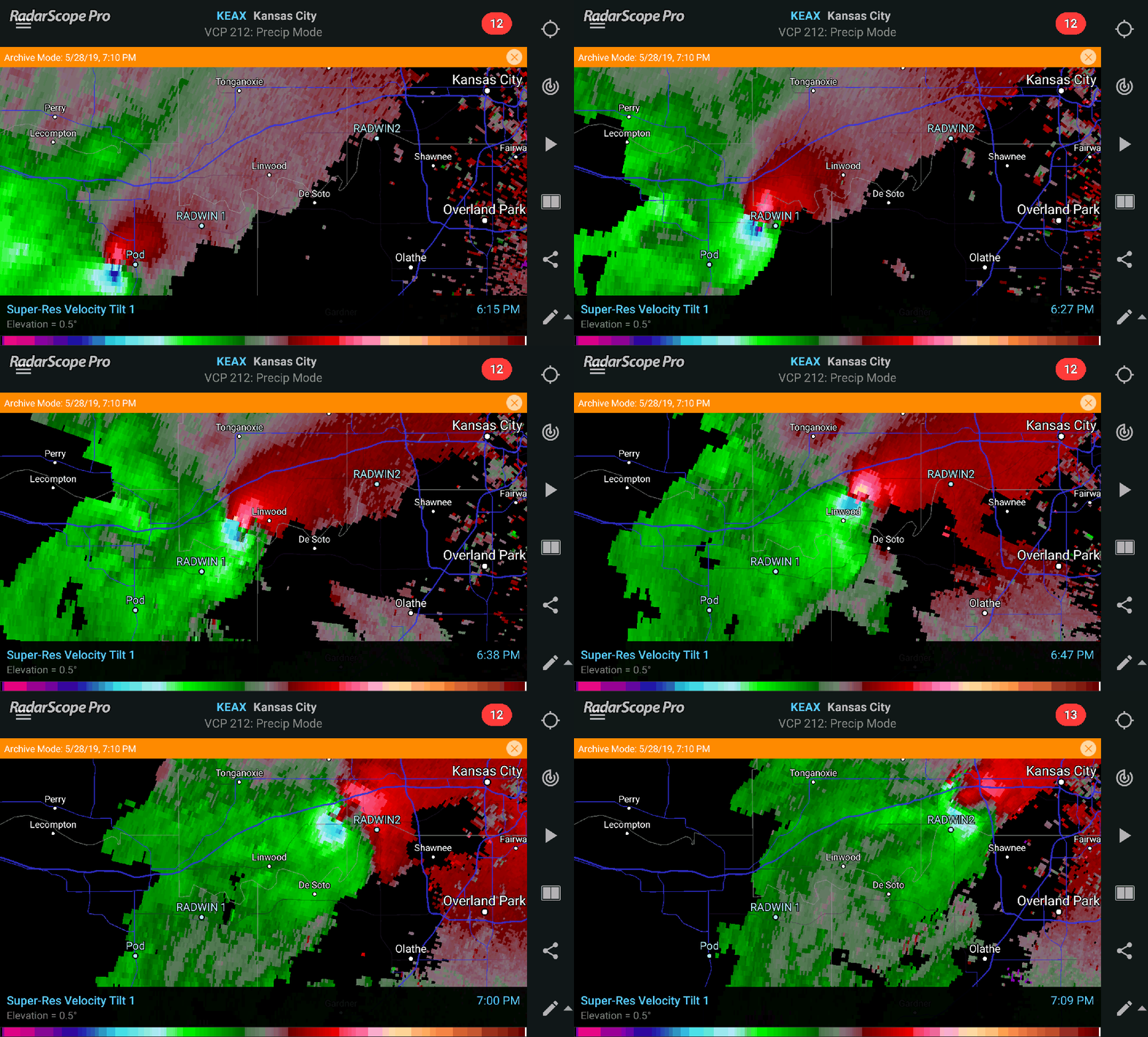
KEAX base velocity view of the tornado’s path. SPECTRA’s instrument placement locations are marked.
This was the first successful deployment for SPECTA (Supercell Thunderstorm Research and Analysis) in 2019. The project has two main objectives when it comes to studying the supercell structure and environment. Using multiple instruments, thermodynamic and dynamic data are collected. The overall project aims to better understand rear flank gust fronts and secondary rear-flank gust fronts and how they relate to tornadogenesis, as well as understanding and computing the Significant Tornado Parameter in proximity to tornadoes and how it relates to overall environmental STP values.
A RADWIN (Rapid-Deploy Weather Instrument) studying inflow data on a Colorado supercell which produced baseball-sized hail in Springfield, Colorado on May 26, 2019.
The workhorse for the SPECTRA project is the RADWIN, or Rapid-Deploy Weather Instrument. The instrument takes about 45 seconds to set up in the field and collects multiple variables including temperature, humidity, pressure, wind speed and direction and pressure data. A rain gauge is also on the instrument to determine when it is raining.
Rear flank downdraft data is collected in Bonner Springs, Kansas as an EF-4 tornado lifts just north of this location.
RADWIN 1 data plotted on KEAX Base Velocity at 6:27 PM CDT.
The first RADWIN was deployed at 6:27 p.m. CDT as the then EF-3 tornado barrels down KS 10 southeast of Lawrence, Kansas. The inflow data was registering a temperature of 75 degrees and a dewpoint at 72. The wind was sustained at 14.3kts at 171 degrees.
RADWIN 1 data plotted on KEAX Base Velocity at 6:29 PM CDT.
At 6:29 p.m., the inflow winds strengthened to 35.5kts at 156 degrees. The temperature fell to 71 degrees and the dewpoint fell to 68. This was the peak inflow wind data over the three minute dataset.
Shortly after 6:29 p.m. the RADWIN station was toppled by strong southwest winds topping 70kts. The impact of the RADWIN caused data collection to be stopped. This wind was either the outer edge of the tornado or strong RFD.
Time series RADWIN data from first collection to the RFD/tornado winds.
The full time series of data shows the tornado’s inflow theromodynamics. While there was a five-degree drop in temperature and three-degree drop in dewpoint, winds were still south/southeast meaning all inflow wind data.
The RADWIN data was likely just outside the tornado’s path, however the final path has not been released by the National Weather Service in Kansas City as if this writing (6/4/19). The pressure data would suggest a close approach with a 3mb drop in 20 seconds. It’s possible the pressure drop would have been more dramatic had the instrument survived the impact with the ground.
This data is exactly what SPECTRA is looking for. The RADWINs are not meant to be in the tornado itself as the higher profile instrument stands more than 2m. This cannot handle the wind speeds inside or near tornadoes, clearly evident in RADWIN 1’s failure.
KIXD RAP sounding at 2300z.
Using SHARPpy and BUFKIT data, the above sounding is the environment in place in close proximity to the Linwood tornado. The environment is certainly capable of tornadoes with effective storm relative helicity of 237 m2/s2. SBCAPE stands at 1948 with 0-3km CAPE at 115.
KIXD RAP sounding with RADWIN data inserted into the surface.
Using the 2300z KIXD sounding and inputing the low-level RADWIN data we can generate a new sounding for that environment. The thermodynamic profile is even more suitable for tornadoes with SBCAPE up to 3525. This is more conducive to stronger, longer-strack tornadoes. 0-3km CAPE goes up to 125.
The Supercell Composite Value jumps by 60 percent up to 16.3 and the Significant Tornado Parameter is up to 3.4.
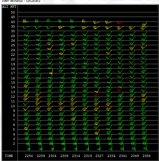
The last addition to this puzzle will be the KEAX radar VAD data. Using the 2327z data, the shear values increase even further. The 0-1km shear increased to 32kts, the effective SRH is up to 263 m2/s2.
Looking at the parameters, the supercell composite increases to 18.5 from 10.8 using the stock sounding. The Significant Tornado Parameter goes up to 3.7 from 1.9.
At the analyzed time the Linwood supercell is 48.4 nautical miles from the RADWIN. The wind profile would likely be even more enhanced if KEAX was able to get a better analysis of the storm-induced environment.
The low-level winds were certainly more backed prior to the storm approaching the radar site. With time the veer-back-veer aloft improved as the storm approached KEAX.
Distance from KEAX to RADWIN 1 was 48.4 nautiful miles. While distant, the VAD data was still in the inflow region of the supercell.
The impact with the ground snapped the radiation shield off the RADWIN and cracked the base of the anemometer.
Retrieving the RADWIN from the field following the tornado.


